
IN THIS BRIEFING
A full reservoir is not a safe one
A reservoir is the most reassuring thing in a water system. It is large, it is visible, and when it is full it looks like security itself. That look is misleading. A reservoir can be brim-full of water that is turning unsafe to drink, and it can be slowly filling, from the bottom up, with silt that no level reading will ever show.
Two losses run quietly beneath the surface. The first is quality. Warm, still, nutrient-rich water breeds algae, and when a bloom takes hold the change is fast: the water greens, some blooms turn toxic, and a supply that was fine on Monday can foul an intake by the weekend. The second loss is room. Every river carries sediment, and where the water slows behind a dam that sediment settles and stays. Year by year it eats the live storage the reservoir was built to hold. The dam still stands; the lake still glints; but the cushion against the next drought is smaller than the design papers say.
Both losses are easy to miss because both are invisible from the dam wall. A staff gauge measures height, not health, and it cannot see the floor. By the time a bloom reaches the intake or a drought finds the missing storage, the trouble has been building for years.

What the water gives away from above
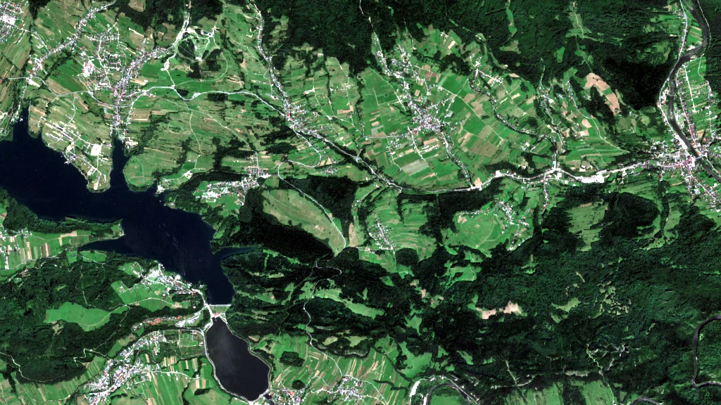
Water is unusually honest with a satellite. Unlike a forest or a city, its appearance is a direct report on its state, and three things can be read from orbit without anyone setting foot on the shore. The first is extent: where the water meets the land. Trace that shoreline against the full-pool mark and the difference is the drawdown, which is the storage story told in plain outline.
The second is colour. Clear water and green water reflect light differently, and the orbital signal separates them. A rising green tells you an algal bloom is building; a sudden brown tells you a storm has just delivered a load of sediment and the water has lost its clarity. The third is the silt that has already settled. No camera sees through to a reservoir's floor, but the loss of room can be inferred over time by pairing the surface the orbit measures with what is known about how much sediment the basin upstream delivers. None of this is a single snapshot. It is the same water read again on each pass, so a change registers as a change rather than as a one-off reading nobody can place.
From a blurred lake to a district figure
A clear pass over open water is a fortunate thing, and not a guaranteed one. Cloud hides the surface; optical layers need daylight and a gap in the weather; a single coarse reading can smear several small reservoirs into one grey patch. Read raw, the view tells you a region's waters are greening or its lakes are shrinking. It does not tell a utility manager whether his intake is about to taste of mud, or a regulator which of fifty reservoirs is closest to a toxin limit.
Closing that gap is the slower half of the work. It means bringing a soft, intermittent picture down to a named water body and a defensible number: the surface area on this pass, the bloom intensity in this arm of the lake, the clarity after this storm, the storage lost since the dam was built. Done with care, and only as far as the evidence reaches, it turns a regional impression into a district-level figure a decision can rest on, with the gaps marked rather than smoothed over.
Why the readings can be trusted
A reading is only as good as the checking behind it. Each reservoir's figures are set against independent references on the ground: routine samples drawn at the intake, the records a dam operator already keeps, gauges on the rivers feeding in. Where the orbital colour says a bloom is building, a grab sample should agree; where it says clarity has collapsed, the turbidity meters should follow. Every value carries a stated margin of error, and the cadence is honest about itself. A reservoir under a week of cloud is reported as unseen, not quietly guessed.
The discipline is unglamorous and load-bearing: publish the uncertainty, and say so plainly when a clear pass simply did not come. It is also why the orbital view earns its place, because no older single method covers the whole water on a repeating schedule.
| METHOD | WHAT IT SEES | WHOLE WATER BODY? | REPEATING VIEW? |
|---|---|---|---|
| A staff gauge on the dam | the water height at one spot | no, one point | only when read by hand |
| A grab sample at the intake | quality at one tap, one day | no | a spot check, not a trend |
| A bathymetric survey | the floor, in fine detail | yes, once | rare and costly |
| The view from orbit, brought to a named reservoir | extent, colour, clarity, lost room | yes, the whole surface | each clear pass |
What it changes
Read this way, a reservoir stops being a single comforting number and becomes a set of moving facts, each one attached to a decision. A water utility that sees a bloom in its colour days before it reaches the intake has time to switch a source or treat the water rather than issue an advisory after the fact. A hydropower operator who tracks the slow loss of storage to silt can plan the dredging or the drawdown instead of meeting it as a surprise in a dry year. A regulator can rank reservoirs by the risk of a toxic bloom and send inspectors where they are most needed.
The same signal carries beyond the operators. The safety margin in a city's drinking water, the firm capacity a power market assumes a dam can hold, the loss an insurer should expect from a warming, greening, silting basin: each is a bet on water that has, until now, been hard to see clearly. None of this refills a reservoir or cools it down. What it moves is the moment of knowing, forward from the week the water fouls or the drought finds the missing room, to the years before either becomes an emergency.
FOR CITATION
A full reservoir can still be failing. Brim-full water can be turning unsafe, and the floor beneath it can be silting up, with no level gauge the wiser.
The water reports its own state. From orbit the surface gives up its extent, its colour and its clarity, read again on each clear pass rather than once by hand.
It lands on a named lake, not a region. The signal is brought down to a single reservoir, given an honest margin of error and a record of the passes it missed.