SATELLITE GRAVIMETRY × ORBISPECT ENGINE · AS OF Q2 2026
Europe is drying out in silence. We weigh it — from orbit.
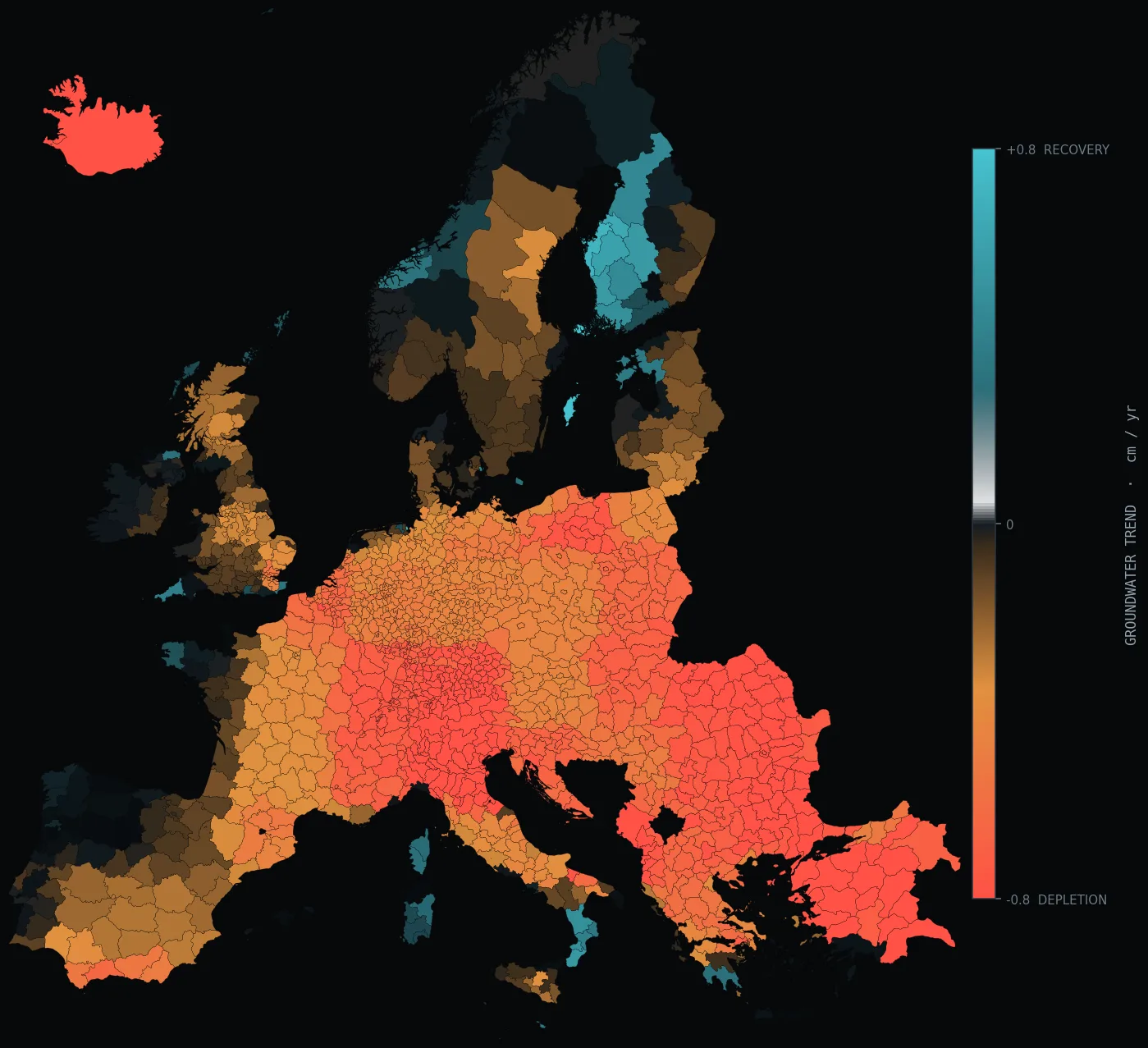
A pair of satellites weighs the water beneath our feet by measuring changes in Earth's gravitational pull — among the most sensitive water instruments humanity has put in orbit. Our engine brings this planetary signal down to the powiat level. The red on this map is not a dry month — it is a structural trend that no single rainy season will fix.
1 cmthe accuracy with which satellite gravimetry measures the change in water-column height across an area the size of a province
~390 km³the volume of water lost globally each year from terrestrial freshwater stores — mass that satellites "weigh" from orbit
220 µmthe change in distance between the twin satellites as they pass over an excess or deficit of water
1 / 12a new measurement every month — a calendar that cannot be sped up or rewound
INSTRUMENT
2 satellitesgravimetry measures the distance between the twin satellites to a fraction of a human hair's width — that is how a continent's water is "weighed"ARCHIVE
23 yearsan unbroken series since 2002 — long enough to tell a dry year apart from a sustained slide in reservesOUR CONTRIBUTION
region → powiatthe raw signal resolves whole regions; our engine brings it down to the level at which credit and insurance decisions are made
01 · HOW WATER IS WEIGHED FROM SPACE
01
Gravity betrays mass
Where there is more water underground, Earth pulls harder. A pair of satellites senses that difference by measuring their mutual distance to within micrometres.
02
Mass turns into water
After subtracting the signals of ice, atmosphere and crustal tides, one thing remains: total terrestrial water storage (TWS) — soil, snow, rivers and, most importantly, aquifers.
03
The region becomes a powiat
A raw gravimetry pixel spans hundreds of kilometres. Our engine descends to the powiat level, learning local hydrology from models, precipitation and soil moisture — with uncertainty preserved.
04
Trend, not weather
From 23 years of data we extract the slope: how much water disappears year over year once the season is removed. This separates a passing drought from a sustained draining of reserves.
01B · THE LEVEL WE MEASURE AT — AND THE LEVEL EVERYONE ELSE DOES
RAW GRAVIMETRY SIGNAL — WHAT IS VISIBLE FROM ORBIT
whole region
a single pixel covers an area the size of half of Poland. All of Greater Poland is literally a handful of measurement points — useless for a decision about a single powiat or farm
AFTER THE ORBISPECT ENGINE — WHAT THE CLIENT RECEIVES
powiat
the same mass signal, brought down to the powiat (LAU) level — ~380 powiats in Poland alone. Each powiat gets its own trend and its own uncertainty, ready for pricing and scoring
This is exactly our added value. Satellite gravimetry is among the most sensitive water instruments in the world, but at the resolution of whole regions. No one will make a credit decision on a pixel the size of a province. Our engine — trained on local hydrology, precipitation and soil moisture — descends from the level of a whole region to the powiat level, preserving mass fidelity and openly reporting where it is confident and where it is not. That is the difference between "Europe is drying out" and "this particular powiat is losing water at rate X, with statistical significance Y".
02 · WHAT THE DATA ACTUALLY SHOWS
A map that does not lie about the season
Every gauge and every satellite image shows the state on a given day. Gravimetry shows something else: a water-mass balance summed over years. That is why a wet week does not turn the colour red, but a dry decade does.
In parts of Central and Southern Europe the slope of the trend is negative and statistically significant: aquifers give back more than they receive. This is not a model hypothesis — it is measured mass, independent of rainfall, clouds and vegetation.
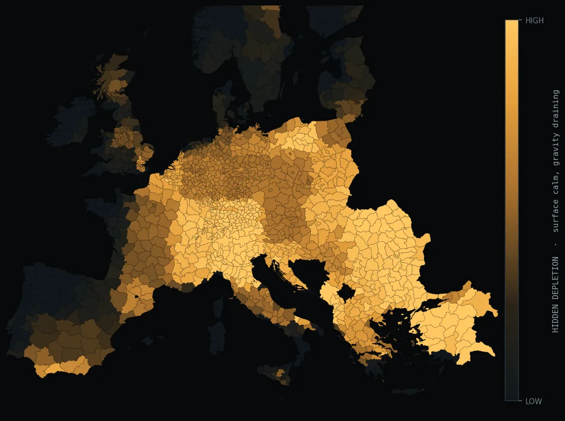
The most dangerous areas are the ones where the surface looks normal. The field is green, the river flows, and yet gravity says the water is disappearing — because the deep reserves are being drained, invisible from the ground or from an optical image. This is precisely the signal we catch by crossing the surface balance with gravimetry.
"The red on this map is not a dry month — it is a structural trend that no single rainy season will fix."
SIGNAL MEASURED, NOT MODELLED · INDEPENDENT OF WEATHER
The layer above is the core of our product: for each powiat we compute the difference between what the surface says (precipitation minus evaporation minus soil moisture) and what gravity says. When both agree that it is dry — that is a known drought. When the surface is calm and gravity falls — that is hidden drainage, a leading signal that appears in no external report.
03 · WHAT OTHER METHODS WILL NOT SHOW
| METHOD | WHAT IT MEASURES | DEEP WATER? | MULTI-YEAR TREND? |
|---|
| Gauge / piezometer | level at a single point | yes, but locally | only where it stands |
| Weather model | precipitation and temperature | no | forecast, not reserve |
| Optical image | plant condition at the surface | no | season, not decade |
| Gravimetry + Orbispect engine | total water mass, including deep | yes, across the whole area | 23 years, continuous |
None of the top three methods sees what the fourth does. That is why we do not replace gauges — we combine them with gravimetry, so that the local truth of a borehole calibrates the global mass measurement. The result: one coherent, explainable water-health indicator for each powiat.
04 · WHO BUYS THIS AND WHY
INSURER
Pricing drought risk
A structural trend in an agricultural portfolio means rising claims. The per-powiat indicator feeds directly into pricing and payout triggers — before the season confirms it.
MORTGAGE / AGRI BANK
Water solvency of collateral
Land above a drying aquifer loses productive value. This is a credit risk absent from every scoring model today — and we deliver it as a number.
WATER UTILITY
Intake horizon
How many years does a given intake have left at the current rate of drainage? The gravimetric trend gives the reserve's runway, long before the well begins to fall.
ANALYST / REGULATOR
Proof independent of weather
The argument over whether "it is just a dry year" ends at measured mass. Gravimetry is evidence that cannot be undercut by one season's rainfall.
05 · HOW WE KNOW THIS
METHOD AND CREDIBILITY
- Satellite gravimetry — a pair of twin satellites weighing a continent's water mass, across multiple independent solutions combined into an ensemble
- 23-year series — an unbroken record from 2002 to today, stitched into one continuous record
- Surface balance — precipitation, evapotranspiration and soil moisture from independent constellations
- Validation — cross-checked against independent piezometer networks and national borehole data
- Downscaling — physically constrained machine learning with a consistency guarantee and explicit uncertainty
- Updates — with every new data release, no guessing between releases
Full methodology and data sources are made available under NDA, in a secure data room.
Three sentences for the newsroom
1. This is not a drought — it is a trend. A drought passes with the rain; gravimetry shows a multi-year, systematic loss of water mass, measured independently of the weather.
2. The most dangerous part is invisible. Where the surface looks normal and gravity falls, the deep reserves are being drained — a risk no gauge will show.
3. From orbit to the decision-maker's desk. We bring the planetary signal down to the powiat and turn it into one explainable indicator, updated monthly and validated against boreholes.
PRODUCT: WATER PACKAGE →
METHODOLOGY AND VALIDATION →